ARTICLE

3D Scanning: A Safe and Effective Solution

Safety, time and money. These are all top-of-mind factors for property owners when trying to determine what improvements are needed for a failing building or structure.

A safe and effective way to better understand existing conditions is utilizing 3D scanning.

How It Works

A 3D scan is obtained by our trained survey technicians utilizing Trimble scanning equipment, producing a point cloud that is analyzed in Trimble Business Center (TBC). The combination of the scan and software can determine existing conditions of the building, both mechanically and structurally, and provide accurate locations where building improvements are needed. 

Advantages

There are many advantages to utilizing 3D scanning prior to making improvements to your building or other structure. Some of these include:

  • It’s safe. Scans can be taken several stories in the air and keep survey technicians safely on the ground.
  • It saves time and money. Depending on the project size, scans can be performed in a day or two compared to conventional survey techniques which may take multiple days. And, it doesn’t require scaffolding or ladders.
  • It puts a picture behind the scan that captures current photographs and 3D modeling.
  • It captures thousands of data points to create surfaces that engineers can utilize to make accurate measurements in their CAD file/drawing.

Applications

3D scanning can be performed on nearly any hard-surface building or structure. Some of the types of projects we’ve applied this method to include: 

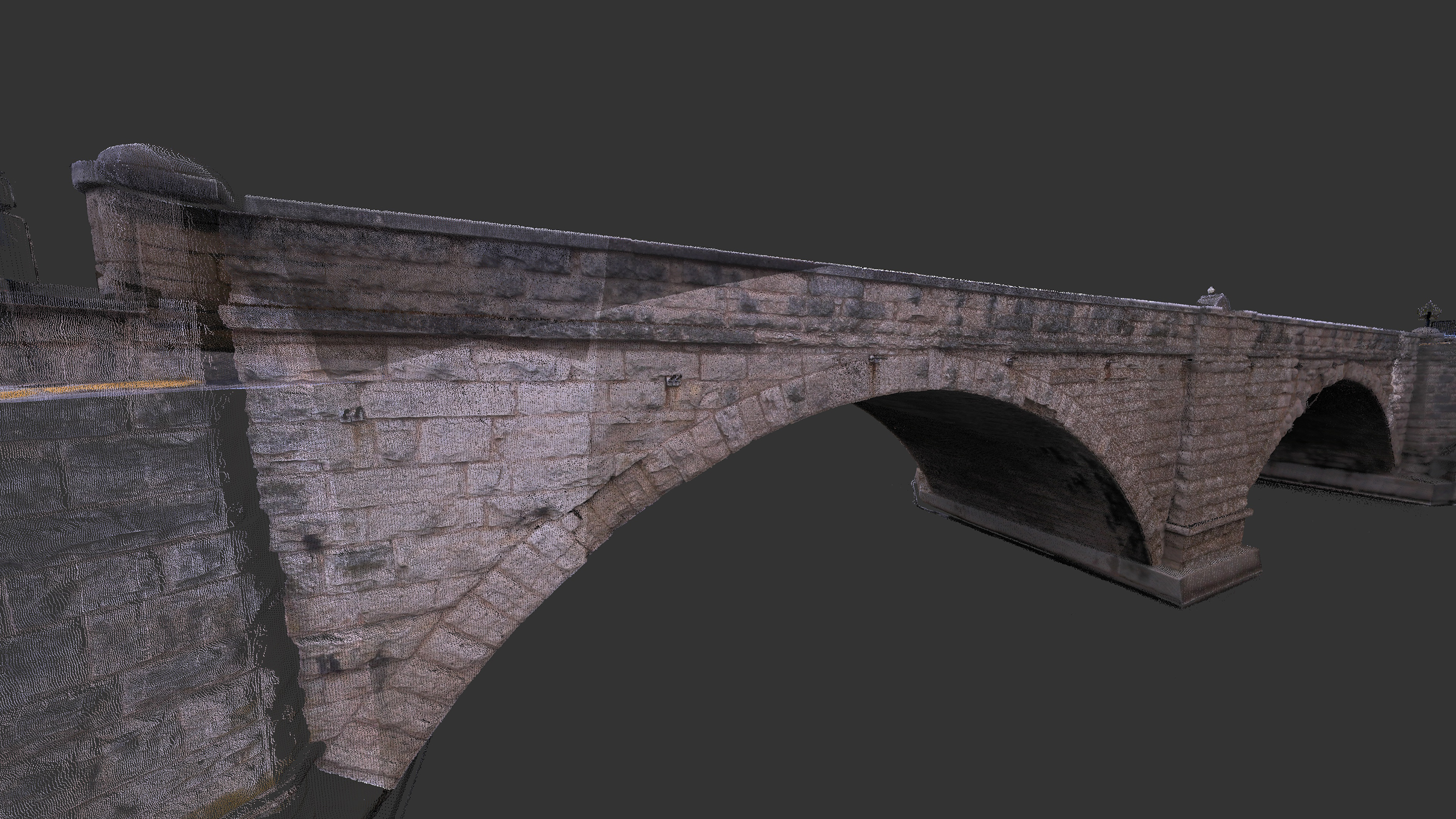
  • Bridges: 3D scans are most often used to obtain measurements. For example, we recently performed a scan of the historic Keystone Bridge in Elkader, Iowa. With 3D scanning, we were able to document the historic arches and identify the depths to run utilities. During design, the scans were used for measurements of the limestone block size and hydraulic openings.
  • Buildings & Walls: 3D scans can look for structural deficiencies and movement over time. This might include an initial scan, as well as a scan—at a later date—to document sinking, tipping, etc.
  • Tunnels: 3D scans gather accurate measurements for equipment, tunnel dimensions, access points and structural support members.
  • Pavements/Parking Lots: 3D scans provide measurements of existing site conditions, such as parking lots, curb and gutter, building doors and window locations.
3D scan of Historic Keystone Bridge in Elkader, Iowa

Delivering Solutions

Another example of a recent 3D scanning project our survey crew performed was for the 100+ year old First Congregational Church UCC in Dubuque, Iowa. The interior and exterior were both scanned. From those scans, we were able to determine how the building lines and roof lines shifted over the years. 

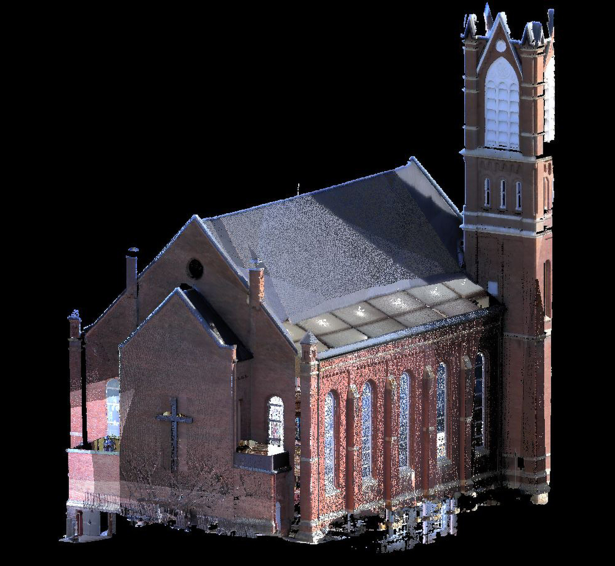
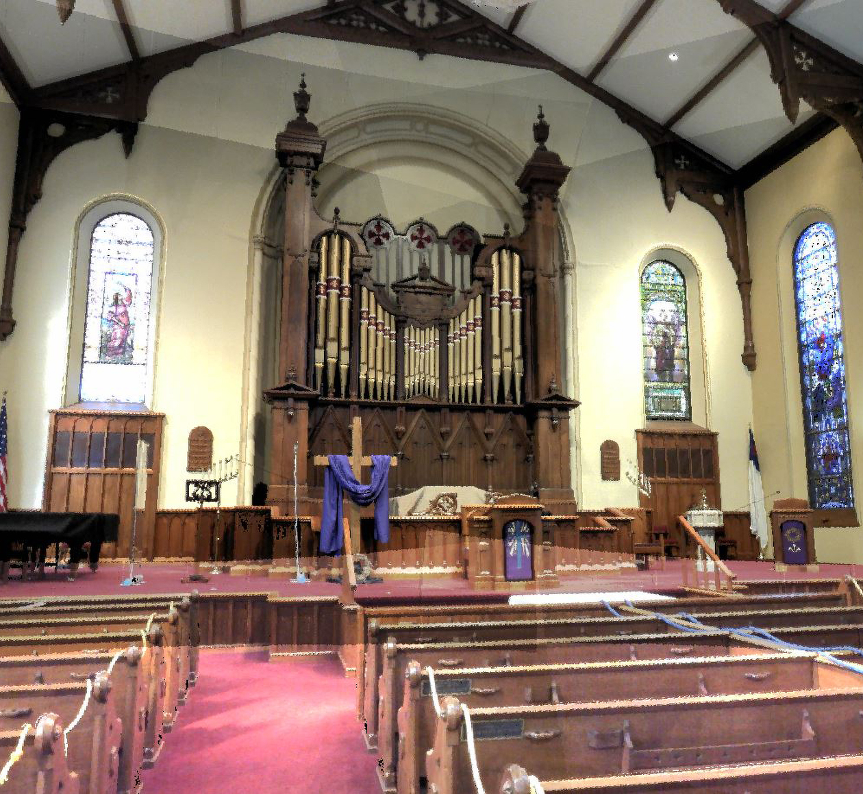
Working with that information, our structural engineers provided an efficient engineering solution to stabilize the structure and make the necessary improvements. 

Commercial Education Energy Government Healthcare Industrial Parks & Recreation Real Estate Development Retail, Gaming & Hospitality Architecture Engineering Structural Land Development Municipal Transportation Water Resources Land Survey Field Services
WORKING ON TOMORROW
CONTACT US

Are you interested in learning more? I can help you determine if 3D scanning is a good fit for your project needs.

ABOUT THE AUTHOR

Craig Geiser, PLS is Team Leader for Origin Design's Land Survey Team, and he also serves on the company's Board of Directors. His experience includes preparation of boundary surveys, topographic surveys, alta surveys, construction staking and determination of proposed and existing right-of-way. He has worked on various projects requiring the interpretation of deeds and descriptions, and how this relates to specific state codes and laws.

Follow our journey.

#workingontomorrow

Our structural engineers recently assisted JLG Architects with this middle school addition in Alexandria, MN. Learn more about the project here.

#origindesign #creatingabettertomorrow


Chris Huseman is celebrating 30 years at Origin Design! We're so lucky to have you on our #origincrew! Happy Anniversary, Chris!

#origindesign #creatingabettertomorrow #itstartshere

#workingontomorrow

We partnered with Logistics Park on the design and construction of a new tower at their East Dubuque operations. 3D scanning was utilized to create a point cloud model of the existing tower. 

Check out these completed photos of the project & learn more here: https://origindesign.com/.../logistics-park-conveyor...

Happy Administrative Professionals Day!

Today (& everyday), we celebrate the administrative professionals who keep Origin Design running smoothly. Your hard work and dedication are appreciated! We truly couldn't do what we do without you!

#AdministrativeProfessionalsDay #origindesign #creatingabettertomorrow

#workingontomorrow

Ever wondered what a storm water pumping station looks like while under construction? Check out these photos from the Maquoketa Storm Water System Improvements project.

Origin Design partnered with the City of Maquoketa and East Central Intergovernmental Association [ECIA] on this project which received funding from Public Assistance Grants from the US Economic Development Administration.

Learn more about the project here.

#origindesign #creatingabettertomorrow

Meet our Architecture team!

At Origin Design, we believe architecture and creative design extend beyond the building to capture the spirit of its surroundings, personality of its users and the needs of our clients.

Our architects work directly with our clients to design spaces that are visually exciting and creative, secure, efficient and innovative.

We're lucky to have this talented group of individuals on our #origincrew!

#architectureweek #creatingabettertomorrow #origindesign #itstartshere

#workingontomorrow

Check out these photos of the Smith Street Bridge over Bear Creek in Shellsburg, Iowa!

Our transportation team worked with the City of Shellsburg to help determine the best outcome for this historic bridge. The result being the addition of a new vehicular bridge downstream, while the existing bridge was rehabilitated into a pedestrian bridge.

Learn more about the project here.

#creatingabettertomorrow #origindesign #itstartshere

Happy 5th Anniversary, Mike McNeil! We're so lucky to have you on our #origincrew! Join us in congratulating Mike on reaching this milestone!

#origindesign #creatingabettertomorrow #itstartshere

#workingontomorrow

Check out these finished photos of the Business 151 project we completed in Platteville, Wisconsin. This 2.1-mile-long project was funded with HSIP funds to create a safer corridor of Business 151 from Staley Avenue to Insight Drive including the signalized intersection of Business 151 with State Highway 80/81.

Learn more about the project here.

#creatingabettertomorrow #origindesign #itstartshere

Happy Land Surveyors Week!

Our team of Professional Land Surveyors and Surveying Technical Specialist round out our Land Survey Team!

Land surveyors ensure precise property boundaries, prevent legal disputes, and provide critical data for safe, compliant construction. They navigate zoning laws, use advanced tech like GPS and drones for accuracy, and help promote sustainable development. Surveyors are essential to every successful project!

#LandSurveying #Surveyorsweek

#workingontomorrow

Origin Design's Land Survey team recently assisted with The Key Hotel site. We presented various options for modifying the parking lot, ultimately reconfiguring it for better flow in and out of the project site. An interim design was also created to support operations until full funding is secured for complete reconstruction.

Learn more about the project here

#creatingabettertomorrow #origindesign #surveyorsweek

Meet our Land Surveying Technicians: Jeff Winter, Chris Huseman, and Mark Nickolas! 

With over 90 years of combined experience, they help collect data for locating land, infrastructure, and property boundaries. They take measurements, record notes, and assist with marking land for construction using tools like GPS and total stations. The job also involves drafting maps, researching legal documents, laser scanning structures, and handling equipment while working outdoors in various weather conditions. They ensure accurate measurements for projects and support engineers and builders with reliable data.

#surveyorsweek #origindesign #workingontomorrow

See all posts